
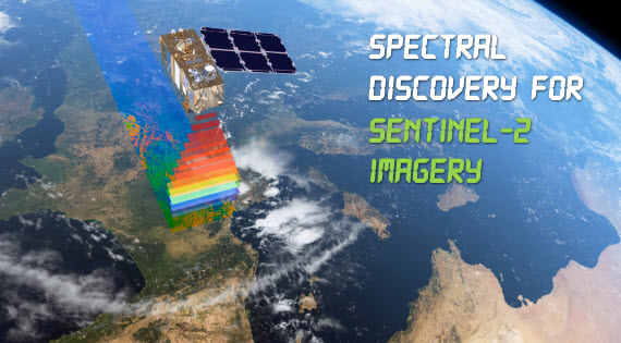
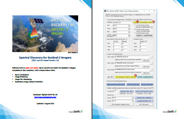
Spectral Discovery for Sentinel-2 Imagery
 |
Advanced software to easily and rapidly make colourful and detail-rich (10m-resolution) Sentinel-2 imagery composite, with 3 simple button clicks.
- Popular software for geospatial professionals and general users. It is productive and saves time!
- Functions include band combinations, image stretching, image pan-sharpening, and exploratory image feature extraction. Perfect software tool to get the daily fresh Sentinel-2 imagery into GIS and remote sensing software, and Google Earth Pro.
- Version 3.1 released in 03/2020
- Recent features
- 1 button click for automated NDVI calculation, with 3 types of outputs (demo)
- 1 button click for automated extraction of surface water areas, with 3 types of outputs (demo)
- batch processing
- supporting the new format of Sentinel-2 Level-1C products published after 12/2016 (link)
- multiple common band combination options included
- support reading Sentinel-2 Level -2A products (03/2020)
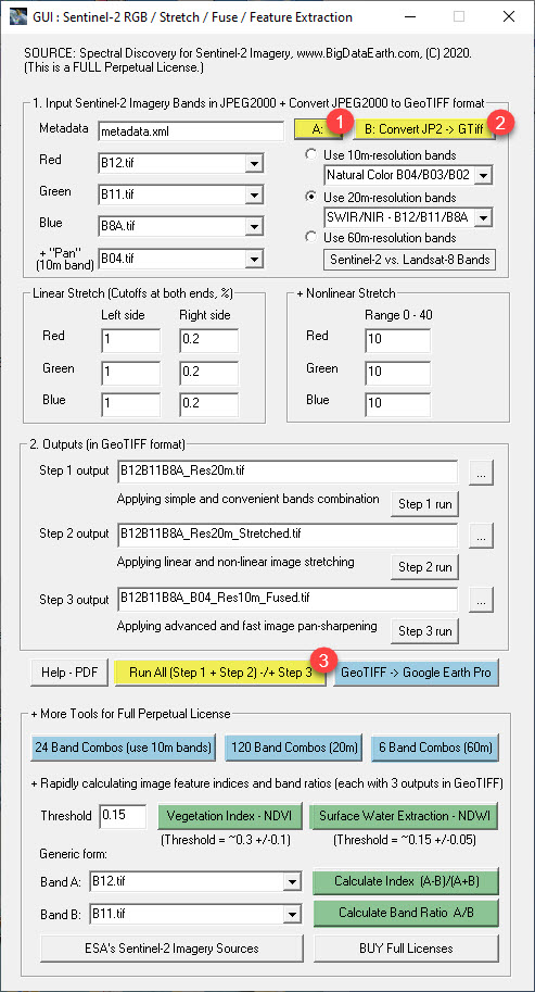
Run software (with 3 button clicks)
- Button 1: Select metadata file (*.xml) of your downloaded Sentinel-2 granule / tile, and the rest of GUI fields will be automatically populated.
- Button 2: Convert downloaded imagery data in JPEG2000 format to uncompressed, analysis-ready GeoTIFF format (assume the most popular open-source GIS software QGIS already installed)
- Button 3: Run three steps altogether (Band Combination, Image Stretching, and Image Pan-sharpening) and output files in GeoTIFF format.
|
|
Sentinel-2 Image Sources
ESA's Sentinel Online provides the most comprehensive information about all satellites from the Sentinel missions, including Sentinel-2. It is always useful to read its user guide, handbook, etc. before conducting proper image processing.
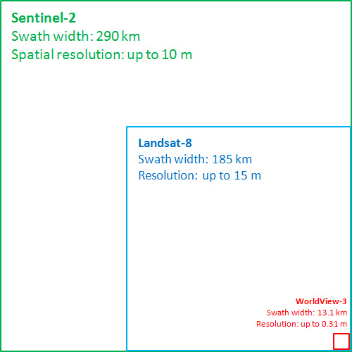
Sentinel-2 (2A and 2B satellites) imaging features wide-swath (290 km), multi-spectral (13 spectral bands), high-resolution (4 visible and near-infrared bands at 10 m, 6 red-edge/shortwave-infrared bands at 20 m, and 3 atmospheric correction bands at 60 m), and high revisit frequency (5 days at the Equator).
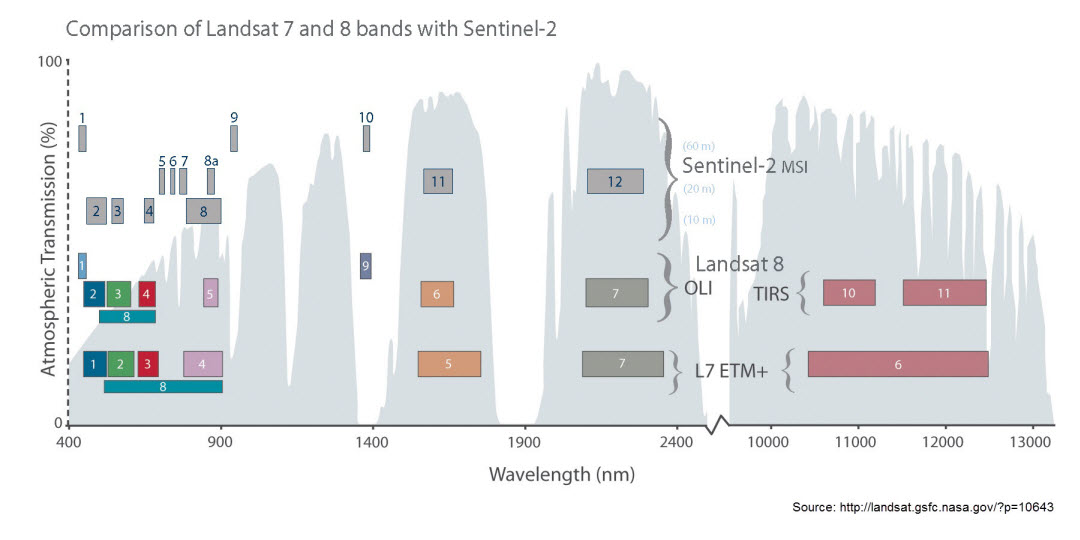
A - Swath width comparisons: Sentinel-2, Landsat-8, and the very high-resolution WorldView-3
B - Comparison of spectral bands between Sentinel-2 and Landsat-8 (the "cousins"): (Source: NASA)
 |
C - Sentinel-2 spectral bands:
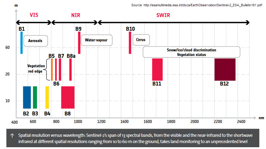 |
Details of 13 bands:
| Band | Name | Central Wavelength | |
| Resolution 10m: | B02 | Blue | 490nm |
| B03 | Green | 560nm | |
| B04 | Red | 665nm | |
| B08 | NIR | 842nm | |
| Resolution 20m: | B05 | Red Edge 1 | 705nm |
| B06 | Red Edge 2 | 740nm | |
| B07 | Red Edge 3 | 783nm | |
| B8a | Red Edge 4 | 865nm | |
| B11 | SWIR 1 | 1610nm | |
| B12 | SWIR 2 | 2190nm | |
| Resolution 60m: | B01 | Aerosols | 443nm |
| B09 | Water vapor | 940nm | |
| B10 | Cirrus | 1375nm | |
Common band combinations for Red/Green/Blue (RGB) imagery composite:
| Sentinel-2 | Landsat-8 | |
| Natural colour | 04 / 03 / 02 | 4 / 3 / 2 |
| Colour infrared (good for vegetation identification) |
08 / 04 / 03 | 5 / 4 / 3 |
| Shortwave infrared (SWIR, good for mapping fire scars or burnt areas) | 12 / 11 / 8a | 7 / 6 / 5 |
D: Sentinel-2 Level-1C data product
Features of the Sentinel-2 Level-1C data product:
- Representing Top of Atmosphere (TOA) reflectance scaled by 10,000
- Applied radiometric and geometric corrections (including orthorectification and spatial registration or georeference)
- GIS / mapping ready cartographic coordinates (with UTM / WGS84 projection)
- A full large scene is divided into a set of granules (also called tiles), each at 100 km x 100 km in size (excluding overlapping edges of 9.8 km). Typical file size of all bands with a granule / tile: ~500 MB (in compressed JPEG2000 format). User can download data for a full scene or an individual granule / tile, up to the download method (introduced below).
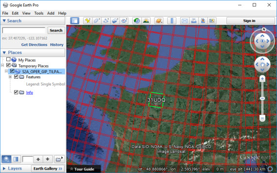
E: Identify granule / tile for your Area of Interest (AOI)
Sentinel-2 granule / tile gridding is based on the NATO Military Grid Reference System (MGRS, GIS files). For quick and easy identification, Sentinel Online is providing a Google Earth KML file: Sentinel-2 Level-1C tiling grid (103 MB, uncompressed). Alternatively, a compressed version can be downloaded here (zip file, ~9 MB only).
Open this KML file in Google Earth, and then locate the tile name in the format [UTM code] / latitude band / square / for your AOI. For example, the tile name for Paris is 31 / U / DQ / (as shown in the figure below).
 |
F: Methods of downloading Sentinel-2 Level-1C data
After knowing the granule / tile name for an AOI, one can start to download Sentile-2 imagery data right away. For example, the Method 1 introduced below is a very easy option.
Method 1: Sentinel-2 on AWS (public bucket sentinel-s2-l1c)
https://registry.opendata.aws/sentinel-2/The use of GUI-based tools (e.g. S3 Browser) or AWS Command Line Interface can make data download very quickly. The User Guide below contains some practical tips on how to quickly download data by folders from AWS S3.
Using easy-to-use web-based mapping Apps, e.g. Sentinel Hub’s EO Browser
https://apps.sentinel-hub.com/eo-browser/
one can get file path of the Sentinel-2 imagery stored on AWS S3.
Method 2: Sentinel-2 imagery on Google Earth Engine and Google Cloud Platform:
https://cloud.google.com/storage/docs/public-datasets/sentinel-2Method 3: ESA's Copernicus Open Access Hub, or directly, map-based imagery search tool (to download large-sized whole scenes, typical file size ~7 GB)
Method 4: USGS EarthExplorer - http://earthexplorer.usgs.gov/ or GloVis - http://glovis.usgs.gov/
Method 5: Copernicus Australasia http://www.copernicus.gov.au/
Detailed methods are introduced in the software User Guide (PDF file).
|
|
|
G: Ready to go: If you have already downloaded some Sentinel-2 granules / tiles, and installed a recent version of open-source GIS software QGIS, then using the Spectral Discovery for Sentinel-2 Imagery is very easy. It may take less than 10 seconds to process a granule / tile and make a beautiful GIS/mapping-ready imagery composite!
New Image Analysis Software Tools
Recently, there are cloud-based platforms to process a massive amount of Earth imagery at the global level. But for the majority of professionals, the main approach for detailed image classification and interpretation is still desktop based, along with important field knowledge that is essential for accuracy assessment and outcome validation.
Spectral Discovery for Sentinel-2 Imagery we are contributing to is a dedicated software tool that promises easy and rapid processing of Sentinel-2 imagery for both geospatial professionals and general users. Unique features on image stretching, image fusion, exploratory feature extraction and batch processing are included in a simple workflow. It performs most common and important image analysis steps:
- Step 1 - Band combination (to make three-band imagery composite)
- Step 2 - Image histogram stretching (to make colourful composite)
- Step 3 - Image pan-sharpening (to make colourful and spatially sharper composite)
- Step 4 - Exploratory image feature extraction with image feature indices (e.g. NDVI and NDWI) and band ratios
Step 1: Simple
and convenient band combination to make three-band
imagery composite
Sentinel2_RGB.exe
<red_band_in> <green_band_in>
<blue_band_in> <RGB_out.tif>
e.g.
Sentinel2_RGB.exe B04.tif B03.tif B02.tif RGB_B04B03B02_Res10m.tif
(for true colour)
e.g.
Sentinel2_RGB.exe B08.tif B04.tif B03.tif CIR_B08B04B03_Res10m.tif
(for colour infrared)
Step 2: Adaptive
linear and non-linear image histogram stretching over the
three-band imagery composite
Sentinel2_Stretch.exe
<red_band_order>
<green_band_order> <blue_band_order>
-s
<image_stretch_band1_left_cut>
<image_stretch_band1_right_cut>
<image_stretch_band2_left_cut>
<image_stretch_band2_right_cut>
<image_stretch_band3_left_cut>
<image_stretch_band3_right_cut>
<nonlinear_stretch_band1>
<nonlinear_stretch_band2>
<nonlinear_stretch_band3>
<RGB_in.tif>
<RGB_stretched_out.tif>
e.g.
Sentinel2_Stretch.exe 1 2 3 -s 2 0.2 2 0.2 2 0.2 10 10 10
B04B03B02_Res10m.tif B04B03B02_Stretched_Res10m.tif
e.g.
Sentinel2_Stretch.exe 1 2 3 -s 0 0 0 0 0 0 0
0 0
B11B8aB05_Res20m.tif B11B8aB05_Stretched_Res20m.tif
Step 3: Advanced and fast image pan-sharpening
Sentinel2_Fuse.exe
<pan-sharpening_method> -s
<image_stretch_band1_left_cut>
<image_stretch_band1_right_cut>
<image_stretch_band2_left_cut>
<image_stretch_band2_right_cut>
<image_stretch_band3_left_cut>
<image_stretch_band3_right_cut>
<nonlinear_stretch_band1>
<nonlinear_stretch_band2>
<nonlinear_stretch_band3>
<pan_band_in.tif> <ms_in.tif>
<fused_out.tif>
e.g.
Sentinel2_Fuse.exe 1 -s 2 0.2 2 0.2 2 0.2 10 10 10
B04.tif B11B8aB05_Res20m.tif B11B8aB05_B04_Fused_Res10m.tif
Step 4: Calculating image feature indices and band ratios
Sentinel2_Feature.exe
<calculation_method> <input_band1.tif> <input_band2.tif> <threshold>
e.g. Sentinel2_Feature.exe 1 B08.tif B04.tif 0.3
Tips:
- Make sure the length of file name/path for each output is less than 256 characters, as the software automatically append file name extensions such as "_Res10m_Stretched.tif". You may shorten or remove some very long folder names first, although the software does check the length of each input and output file name/path.
- Please note that the first input to the software is the metadata file (*.xml) specific to the granule/tile, not the metadata file (also in *.xml) specific to the whole scene.
- File names for all outputs are automatically populated by the software, so usually there is no need to modify those names.
- If a scene contains a large proportion of white objects (e.g. cloud and snow), try to increase the right-end cut-off values in image stretching for their exclusion.
- To improve the brightness of the imagery composite, one may increase non-linear stretching values to 10, 20, 30 and so on.
- Once comfortable with a set of linear and non-linear stretching options for a single band combination (at 10m-, 20m- or 60m-resolution bands, respectively), the user may start to run batch band combinations at a corresponding resolution level.
- Output files from image stretching and pan-sharpening, if exist, will be over-written automatically.
- The same procedure equally works for any three-band combinations. Through iterations, any number of multispectral bands can be fused or pan-sharpened.
- In pan-sharpening, the higher resolution RED band (Band 4 at 10m resolution) is commonly selected as an ideal "Pan" band in order to achieve sharper results.
- To process 100s or 1000s of granules / tiles, one may use the DOS-based command-lines directly.
- The software needs to allocate a max of ~1.2 GB RAM for the pan-sharpening process, and this may cause a specific run to fail IF the machine has limited RAM and/or fragmented RAM. If this occurs, please try to run the software on a more powerful machine with sufficient RAM (e.g. 8 GB or more).
Run time:
Spectral Discovery
for Sentinel-2 Imagery is very productive. The time to process a full
Sentinel-2 granule / tile on an average office computer is far less than 1 minute. Detailed
estimates are as follows:
- Step 1 (band combination): 1-5 seconds
- Step 2 (image stretching): 5-15 seconds
- Step 3 (image pan-sharpening): 10-60 seconds
Notes:
It is with great privilege that we all have access to
another superior imagery source. We are very motivated and
have tried our best to develop the tools that can
preserve that high quality as much as possible.
We are confident that anyone even with limited image processing experience can perform the above analysis. It is our hope that more people can take advantage of and benefit from the excellent Sentinel-2 imagery. Thank you, the Copernicus Programme and ESA!
Rapid Processing for Innovative Applications
This unique software can be useful for a wide range of environmental studies, including:
- Monitoring land cover changes (e.g. deforestation and urban expansion)
- Mining exploration and mineral detection with SWIR bands
- Precision agriculture and vegetation mapping (e.g. NDVI)
- Natural hazards (e.g. fire scar mapping, flooding, volcanic eruption)
- Updating GIS basemaps with the latest fresh imagery
Three more button clicks: To rapidly make many band combinations using Sentinel-2's full spectral bands in a batch mode:
- 24 = 4x3x2, using 4 multispectral bands at 10m-resolution - Bands 02, 03, 04, 08 (~10 GB disk space required for each granule / tile)
- 120 = 6x5x4, using 6 multispectral bands at 20m-resolution - Bands 05, 06, 07, 8a, 11, 12 (~12GB disk space required for each granule / tile)
- 6 = 3x2x1, using 3 multispectral bands at 60m-resolution - Bands 01, 09, 10 (~0.1 GB disk space required for each granule / tile)
A simple yet extremely powerful way of image (visual) analysis: Through rapid, various band combinations, important features/phenomena of interest on Earth land surface can be better highlighted and revealed.
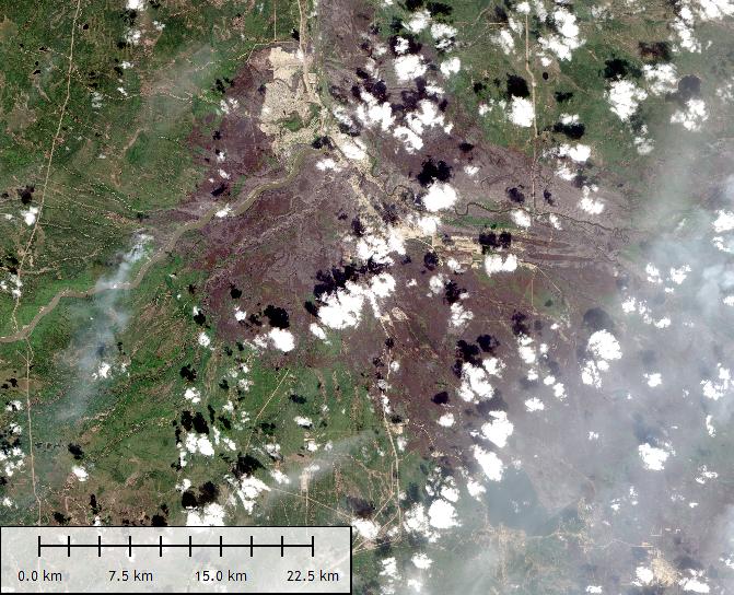
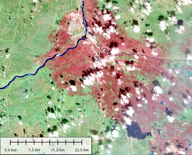
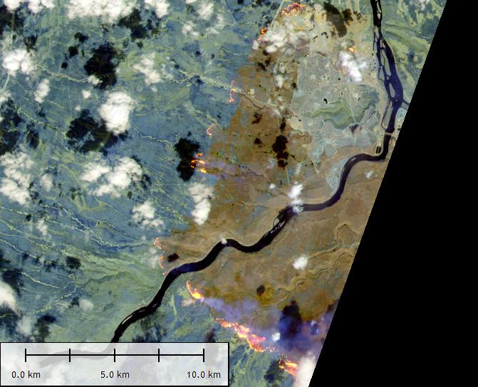
Example 1: Mapping fire scars (burnt areas) with numerous band combinations in an automated procedure. Massive fire scars from the May 2016 Fort McMurray Fire, Alberta, Canada. Left: Natural colour imagery; Right: False colour SWIR imagery. Tile name: 12/V/VH; Date: 2016/5/12.
See the Detail: Advanced Image Fusion and Pan-sharpening
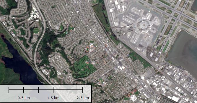
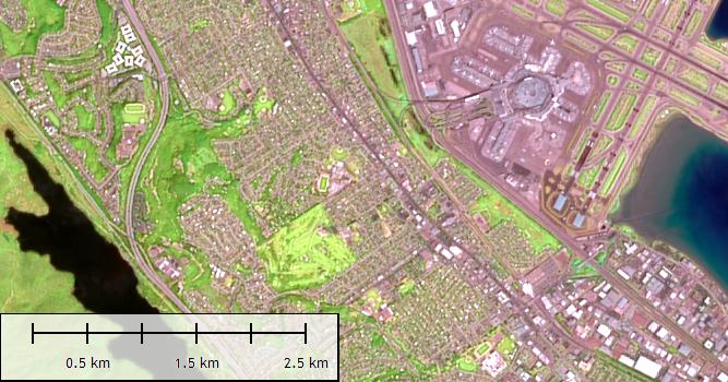
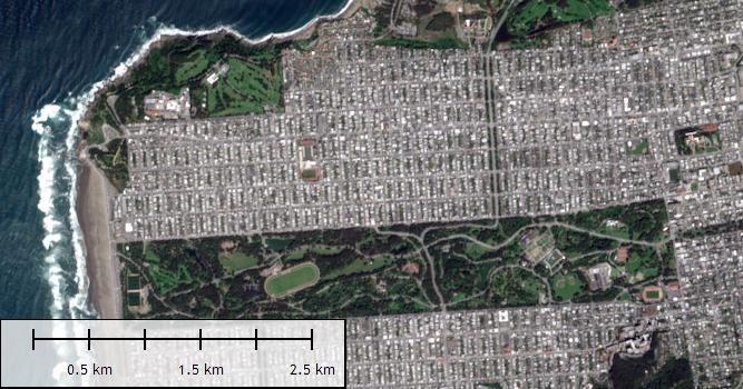
(A) Compare spatial resolution from a pan-sharpening process. Left: Natural colour imagery (B04/B03/B02) at original 10m resolution; Right: False-colour imagery (B11/B8A/B05) pan-sharpened at 10m resolution. Tile name: 10/S/EG; Date: 2016/4/15. Location: San Francisco.
(B) Compare images before and after pan-sharpening. Left: False-colour imagery (B11/B8A/B05) at original 20m resolution; Right: False-colour imagery (B11/B8A/B05) pan-sharpened at 10m resolution. Tile name: 10/S/EG; Date: 2016/4/15. Location: San Francisco.
(C) Compare images before and after pan-sharpening. Left: False-colour imagery (B10/B09/B01) at original 60m resolution; Right: False-colour imagery (B10/B09/B01) pan-sharpened at 10m resolution. Tile name: 32/U/LB; Date: 2016/5/8. Location: near Cologne, Germany.
Example 2: Unique pan-sharpening of Sentinel-2 imagery from coarse 20m- or 60m-resolution to very sharp 10m-resolution. In these cases, a higher resolution (10m) band - Band 4 (red band) - is used as the "pan" band for pan-sharpening.
See the Invisible: Exploring Unique Short-wave Infrared Bands
Like Landsat-8, Sentinel-2 short-wave infrared (SWIR) bands are capable of detecting wildfire hotspots and lava flows/heat through smoke.
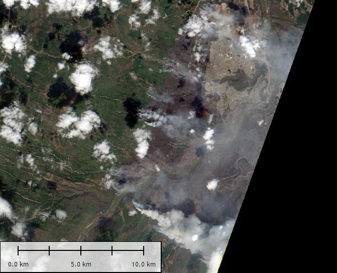
Example 3: The May 2016 Fort McMurray Fire, Alberta, Canada. Left: Natural colour imagery showing full smoke; Right: False-colour SWIR imagery. Tile name: 12/V/VH; Date: 2016/5/5.
See Features of Interest (FOI): From Pixels to Information
Exploratory image feature extraction with image indices (e.g. Normalised Difference Vegetation Index - NDVI, Normalised Difference Water Index - NDWI, Normalised Difference Urban Index, Normalised Difference Snow Index, Burned Area Index) and various band ratios, for a wide range of environmental studies.
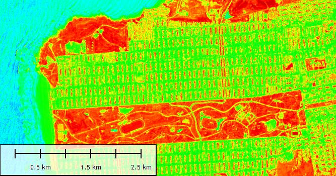
Example 4: Calculating feature indices with three types of outputs automatically from the software. Left: Natural colour imagery; Right: NDVI. Tile name: 10/S/EG; Date: 2016/4/15. Location: San Francisco.
See the Big Picture: Using Global Imagery Mosaics
Need a global satellite
imagery mosaic? Please take a look at the high-quality global satellite
imagery mosaics (30m-resolution, multiple styles) in ELS2000 series.
Automated, exploratory land cover classifications at 10m resolution, at the global scale (ongoing)
Land cover changes
Near real-time / daily monitoring
...
Processed Samples
 |
The imagery data for each Sentinel-2 granule / tile is from AWS. Please make sure you do download input imagery for each granule / tile based on its whole data folder, not one file by one file; otherwise, the download process might be too laborious. All outputs are based on the auto parameterisation in the software.
Evaluation Stretched or pan-sharpened result at 10m resolution in GeoTIFF, ready to be used in all GIS and mapping software (e.g. QGIS, ArcGIS, MapInfo), popular image-editing software (e.g. PhotoShop), and Google Earth Pro. |
For demo only, output image in JPEG
format is included in zip
download below: |
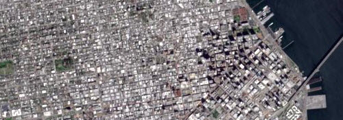 |
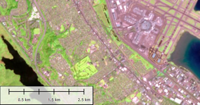
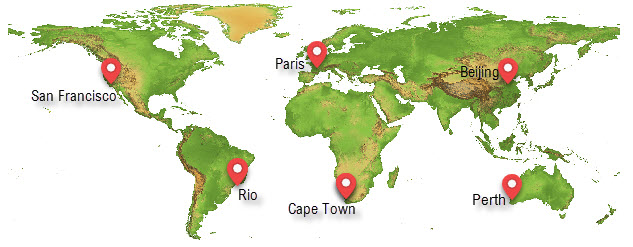
San Francisco Tile name: 10/S/EG |
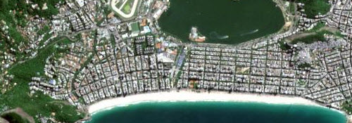 |
Rio de Janeiro Tile name: 23/K/PQ |
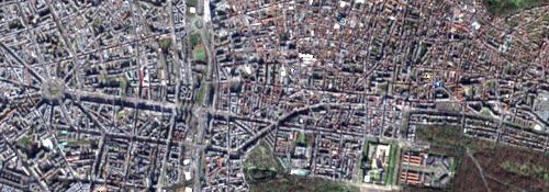 |
Paris Tile name: 31/U/DQ |
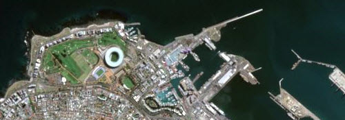 |
Cape Town Tile name: 34/H/BH |
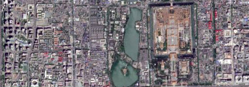 |
Beijing Tile name: 50/T/MK |
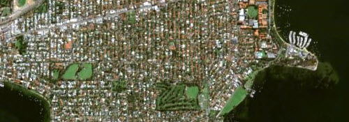 |
Perth Tile name: 50/H/LK |
It only takes ~10 seconds to process each granule / tile
on an ordinary computer. All daily
scenes can be processed as above and efficiently
delivered as soon as they are available in the
following formats (for professionals in remote sensing
and GIS fields, as well as the general public):
- Conventional GeoTIFF
- JPEG2000
- KMZ (Google Earth)
- Various web mapping
tilesets, e.g. Google Map Tiles, Bing Maps Tiles,
OSM Tiles, TMS Tiles
Like Landsat-8, the potential for the broadest use of the new
Sentinel-2 imagery is great.